Travel to Spiti Valley in Himachal Pradesh had been on my mind since few years. But it only materialized in June this year. I only had a vague idea that Spiti valley is similar to Ladakh, but perhaps a little less known than its more famous counterpart. I just jumped in and booked my travel with Spiti Valley Tours, without much research, and also well in advance (almost 4 months in advance!). The journey took us through some of the most stunning landscapes I have come across, while cruising through Kinnaur, Lahaul and Spiti districts of Himachal Pradesh.
There are 2 ways to reach Spiti valley. One from Manali and another from Shimla. The main town in Spiti valley is Kaza. Manali – Kaza is a shorter route, but gains altitude more drastically than the other leisurely route from Shimla. Our plan had us going via Shimla and coming back via Manali.
Kinnaur and Spiti are in total contrast to each other. Kinnaur is more rain soaked and draped in greenery whereas Spiti is barren and dry.
This is first part of a two-part story of my journey through Himachal Pradesh. Its a longish post – so, grab a cup of coffee/tea and come with me on this epic journey – through Kinnaur district.
Our journey started in Chandigarh. We were met by a very genial person, who would drive and accompany us over the next week or so – Munish. Our first day’s goal was to reach a town called Narkanda, which is typically 6 hours of travel from Chandigarh. We would learn a whole lot of things that day, including the basic fact that travel times can change drastically!
It was a Saturday morning, that we started from Chandigarh airport. Munish informed that the journey is going to take longer than 6 hours – how much longer, was an unknown yet. Right from the start of the journey, we could see 2 of the 4 lanes of the highway connecting Chandigarh and Shimla were closed in many places. We witnessed bounders and stones of an assortment of sizes, which had made their way down from the hill slopes and onto the roads – result of a heavy and torrential rain for 3-4 hours overnight. The traffic was also quite high – a typical weekend rush, Munish informed, of Shimla-bound crowd. With this, we silently took a deviation to skip Shimla altogether, by going through smaller but more beautiful peaceful Chail-Kufri road. After a sumptuous lunch at an unassuming dhaba near Chail, we rejoined the main highway somewhere after Shimla.


Munish had already received word from his network of friends, of possible road closure ahead. And so it was. A 6-8 KM section of highway between Shimla and Theog was closed for vehicular traffic and small vehicles (cars and two wheelers) were rerouted. This alternate route involved a steep downhill section and then a steep uphill section. Roads were narrow and bad in patches. Clearly they were not designed to cater to this much traffic, so we ended up having mini traffic jams at multiple places. Though was only 20KM more than the original route, it took us almost 2.5 hours to cover this stretch! After rejoining the main highway, we stopped for a much needed tea break. All this meant that we reached Narkanda pretty late in the evening.
Still in the Shimla district, this little town is famous as a skiing destination in winters.It boasts of oh-so-pretty visuals of hill slopes draped in pine trees and a sprinkling of apple orchards in several places. We had reached just around sunset time and fortunately, our hotel had a nice vantage to the said views! I chose to put my camera to work (for the first time on this trip), even before checking into our hotel room.

Night turned colder – a sign of things to come. We spent most of the time by the bonfire and were ready to retire for the day after a hot meal. The next morning started out gloomy and soon enough, it began to rain. This was the only image I managed before the rains. We had a light breakfast as per Munish’s instructions, because he had promised something special for our taste buds later in the day.

We started while the rains continued to pound down at Narkanda. Thankfully, the intensity of the rain gradually decreased and stopped about an hour into the journey. We were in the company of Sutlej river and started following it upstream. Roads were thankfully good with only a few occasional bad patches. We stopped at a road side dhaba, which had really nice views of the hills beyond the valley in which Sutlej was roaring. True to his promise, we ended up relishing the most delectable Makki ki roti with Sarson ka saag with a generous amount of butter. It was a welcome break from the journey, a treat to our tummies and a sight to behold for our eyes!

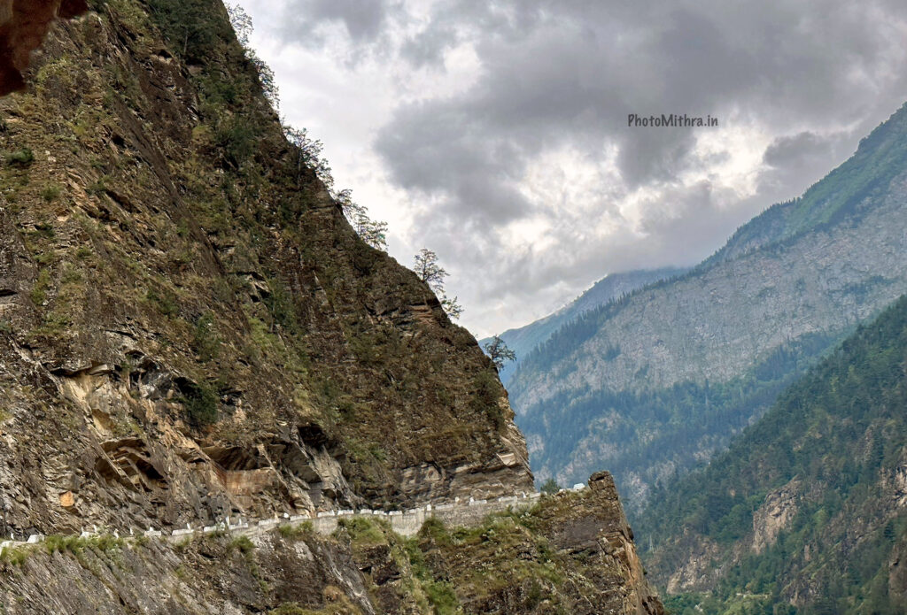
Soon after lunch, we entered Kinnaur district. We had to stop at a check post and fill out details. Apparently, this is to keep track of people entering the district so that people can be traced and contacted in the event of any natural disaster. We are probably used to hill roads having a slopes on either side. But in Kinnaur (and Himachal in general), hill sides are perpendicular to the road and at places, the rocky hills are cut in a way to form a roof over the road! Situated in such a stretch of road is the Taranda Maa temple. It is believed that Taranda Devi protects people travelling on this road, and as such, forms a default stop to offer prayers here before proceeding.


This road continues till Karcham, where we deviate towards Sangla. Otherwise, the road continues towards Tabo. From here, we follow a tributary of Sutlej, called Baspa. As if the roads so far were not challenging enough, the road from Karcham to Sangla is even more precarious. If two big vehicles come from opposite directions, one of them would have to start going reverse till one of the few points where the road is a little bit wider. A recipe for sweaty palms, tingling backs and elevated heart rate.
Sangla is the main village in the valley formed by Baspa river. Our stay was a little beyond Sangla, near a village called Batseri. All the difficulties on the challenging and dangerous roads is completely forgotten once you get a glimpse of the mesmerizing beauty of this lovely valley. At places, you can reach the riverside and just sit in peace. Go across the river over one of the several foot bridges in the area, and you can stroll up and down such gems of Himachali villages of the valley. We hiked up to the Batseri village on the other side of river and it looked like we had gone back in time. The mighty hills are ever present entities all around us – the silence of the valley is only disturbed by the roar of the river, the howl of the winds and calls of birds. Its like a life right out of a fairy tale. While things look rosy for us tourists, the local life can be hard. Remote location, need to travel long distances, often by foot, extreme weather conditions and yet, the genuineness and warmth of the locals is something you cannot miss. These mountain folks are just built differently. It was during our time here that news of heavy rains wreaking havoc in Shimla, Manali were going around nationwide. Several of us got calls from back home inquiring about our safety. For the local people, this was a regular day and they experience this type of situation several times a year. Fortunately, we were blessed with kind weather – not just here, but through out our trip. I could go on and on about Sangla, but I’ll stop here and let some images talk for themselves. All in all, Sangla is a place one should NOT miss!


Our journey from Sangla to Kalpa had a few back and forths. We first headed towards Chitkul, made a stop at Rakchham and then proceed to Kalpa.
Chitkul is dubbed India’s last village. This is debatable. Munish also agreed there are more villages down the same road further. It used to be the last inhabited village along this region and that kind of became a phrase that stuck on. It is a quaint, small village that could offer a meaningful peek into life of the villagers. But sadly, it is thronged by noisy crowds who are only interested in a photo op with the board proclaiming it as “India’s last village” (not the one shown below – this was some distance before the village). The village itself can be explored on foot. The route between Chitkul and Rakchham is very beautiful. We can find several mountain streams gushing down the slopes and adding to the volume of Baspa. We cross several such streams right beside the road along this route. Here are a few images.


Again passing through Sangla, we make a quick lunch stop and then proceed to Kalpa. Kalpa is a small village in the Sutlej valley with excellent views of the snow capped Kinner Kailash mountain ranges. Among the mountain skyline, the Kinner Kailash shivling is easily visible on a clear day. This is a place of great religious belief for the local people and September sees 2-3 days journey on foot that locals undertake to offer pooja at the sacred site situated at an altitude of over 19000 ft. The place we stayed at Kalpa had lovely views of the Kinner Kailash range and clouds offered some dramatic scenes that evening.

In today’s journey, we slowly start transitioning from typical Kinnaur landscapes to Spiti landscapes. The surroundings start to turn more and more dry, and we start seeing the typical deep blue skies dotted with cotton ball clouds. We are still following Sutlej river, but we encounter the confluence of Sutlej and Spiti rivers at Khab. The confluence of two rivers show slightly different shades of brown, but there was not much to differentiate the two rivers apart from the directions they were coming in from. At this point, we bid goodbye to Sutlej and start following Spiti river, which will lead us into Spiti valley. Before we enter Spiti, we make a stop at the last location in Kinnaur district.
Nako is a village close to the border with Tibet. Situated at an altitude of 11800 ft, Nako village consists of a houses clumped together with narrow and labyrinthine alleys running in between. A prominent place in the village is a man made lake considered sacred by locals. On the day we visited, the lake sparkled in a deep shade of emerald green and looked stunning with a deep blue sky in the backdrop. The houses are made of mud/clay and optionally a layer of stones outside. This helps regulate temperature, especially crucial in the cold winters that the region endures each year.


After Nako, we continue our journey towards Tabo. Soon, we formally enter Lahaul and Spiti district at Sumdo. Again, a checkpost collects all traveller details before letting us continue. The landscape and changes therein, have already shown us what to expect over the next few days we were to spend in the Spiti valley. Its difficult to imagine the scale of monumentally awesome landscapes we were still to encounter. Kinnaur hosts some of the most beautiful places in Himachal Pradesh. And I cannot wait to go back and explore more of this area, hopefully in the near future. Watch this space for the next part of our journey through Spiti valley!
Here’s the link to twitter thread that I was live updating though the course of this journey.
Here’s a guest post on Raacho trekkers that I wrote, based on my twitter live feed.
Wao! Amazing journey Made me to get the real feel of the place you visited